
 Nepal
Nepal – Himlung Himal (7,126m)
Himlung Himal (7,126 m) – Kathmandu, Besisahar, Koto, Meta, Phu Gaon and the Nar–Phu region
- Departure
- October 11 – November 6, 2027
- Duration
- 27 days / 26 nights
- Highest point
- 7,126 m
- Difficulty
- T3 K4 V2 Highest grades on the tour, Mountaineering Association of Serbia scale. T3: very demanding trail; K4: over 9 hours walking; V2: 500 to 1,000 m ascent.
- Time difference
- +3 h 45 min When it is 12:00 in Belgrade, it is 15:45 in Nepal. Tip: for a few days before departure, go to bed and get up half an hour to an hour earlier each day, so the time change is easier on you.
- Price per person
- 5,350 EUR
About the expedition
“There are mountains that win us over with their beauty. There are those that draw us with their challenge. And there are rare peaks that give us the feeling that we have stepped into the last truly wild landscapes of the Himalayas. Himlung Himal is exactly one of them.“
Nepal is home to the highest mountains in the world, but also to many hidden valleys in which almost nothing has changed for centuries. Far from the busiest trekking routes, in the remote Nar–Phu region, right on the border with Tibet, rises Himlung Himal (7,126 m) – one of the most accessible 7,000+ m peaks in the world and the dream of many mountaineers who want to take the next big step in their mountaineering development.
Himlung Himal lies in the north of Nepal, between the Annapurna and Manaslu massifs, right beside the Tibetan border. Although it was first climbed only in 1992, today it is considered one of the most beautiful and most accessible peaks for experienced high-altitude mountaineers who want to gain experience at altitudes above 7,000 metres.
The expedition is carefully designed to allow gradual acclimatisation and the maximum chance of a successful ascent. During the first part of the trip we pass through one of the least visited areas of Nepal, following the ancient trading routes that have linked Nepal and Tibet for centuries. Traditional villages, Buddhist gompas, glacial valleys and almost untouched mountain landscapes make this route one of the most authentic in the whole Himalayas.
On arrival at Himlung Himal Base Camp (4,850 m) the expedition part of the programme begins. After final preparations and an equipment check comes multi-day acclimatisation through rotations between base camp and the high camps C1 (5,450 m), C2 (6,150 m) and C3 (6,375 m). During the ascent crampons, an ice axe, fixed ropes and complete high-altitude equipment are used, while safety and logistics are provided by an experienced Sherpa team.
Although it is not technically among the most demanding 7,000+ m peaks, Himlung Himal is a serious high-altitude challenge. The great altitude, extreme weather and a multi-week stay far from civilisation call for excellent physical preparation, discipline and team spirit. For many mountaineers Himlung Himal is their first 7,000+ m peak and a natural step towards the highest peaks in the world.
Itinerary
Day 1Kathmandu
On arrival in Kathmandu, a transfer to the hotel and check-in are organised. After a rest we tour the Thamel district, the mountaineering centre of Nepal. This is an opportunity for a final equipment check, hiring any missing high-altitude equipment and getting to know the city from which the greatest Himalayan expeditions have set off for decades. In the evening a detailed expedition briefing is held – we discuss the ascent plan, acclimatisation, logistics and safety procedures.
- 3★ hotel
- Breakfast
Day 2Kathmandu – Besisahar1,400 m
- Route
- Kathmandu → Besisahar
- Altitudes
- 1,400 m → approx. 760 m
- Driving time
- 6–7 hours
We leave Kathmandu and set off for western Nepal. The road leads through fertile valleys, traditional villages and terraced fields, which are one of the hallmarks of the Nepali landscape. Arrival in Besisahar marks the start of our approach to the Himalayas.
- Lodge / Guesthouse
- Full board
Day 3Besisahar – Koto2,600 m
- Route
- Besisahar → Koto
- Altitudes
- 760 m → approx. 2,600 m
- Driving time
- 7–8 hours
We continue the drive along a mountain road up the valley of the Marsyangdi river. As we climb, the landscape gradually changes – subtropical vegetation gives way to pine forests, and the first high peaks of the Himalayas appear on the horizon. Arrival in Koto is the last point on the main Annapurna Circuit trekking route before turning off towards the remote Nar–Phu region.
— TREKKING PHASE —
- Lodge
- Full board
Day 4Koto – Meta3,560 m
- Route
- Koto → Meta
- Altitudes
- 2,600 m → approx. 3,560 m
- Walking time
- 6–7 hours
- Grade (PSS)
- T1 K2 V2
Today we leave the main trekking route and enter one of the least visited regions of Nepal. The trail follows the deep gorge of the Nar Khola river, passes through dense pine forests and several suspension bridges, and then climbs steeply to the plateau on which the small settlement of Meta lies. For the first time we feel the true wilderness of the Himalayas.
- Lodge
- Full board
Note With about 960 m of ascent this is the day with the biggest altitude difference of the whole expedition.
Day 5Meta – Phu Gaon4,080 m
- Route
- Meta → Phu Gaon
- Altitudes
- 3,560 m → approx. 4,080 m
- Walking time
- 6–7 hours
- Grade (PSS)
- T1 K2 V2
We continue through wide high-mountain valleys surrounded by rocky cliffs and snowy peaks. As we approach Phu Gaon, the landscape increasingly resembles Tibet. Traditional stone houses, prayer walls and Buddhist stupas bear witness to the strong Tibetan cultural influence. Arrival in Phu Gaon is one of the most striking moments of the whole expedition.
- Lodge
- Full board
Day 6Phu Gaon – Acclimatisation Day
- Highest altitude reached
- approx. 4,500–4,700 m
- Activity duration
- 4–5 hours
- Grade (PSS)
- T1 K1 V2
Acclimatisation is one of the key elements of a successful expedition. During the day we organise a short ascent above the village so that the body can gradually adapt to high altitude. From the surrounding viewpoints there are impressive views of the surrounding peaks and plateaus of northern Nepal. On returning there is plenty of time to look around the village and get to know the traditional way of life of the local people.
- Lodge
- Full board
Day 7Phu Gaon – Himlung Himal Base Camp4,850 m
- Route
- Phu Gaon → Himlung Himal Base Camp
- Altitudes
- 4,080 m → approx. 4,850 m
- Walking time
- 5–6 hours
- Grade (PSS)
- T1 K2 V2
We leave the last permanently inhabited settlement and set off for base camp. The trail passes over wide moraines and glacial valleys, while the Himlung Himal massif gradually opens up in front of us. Arrival at base camp marks the start of the real expedition. We settle into tents, get to know how life in the camp is organised and prepare equipment for the coming days.
— EXPEDITION PHASE —
- Expedition tents
- Full board
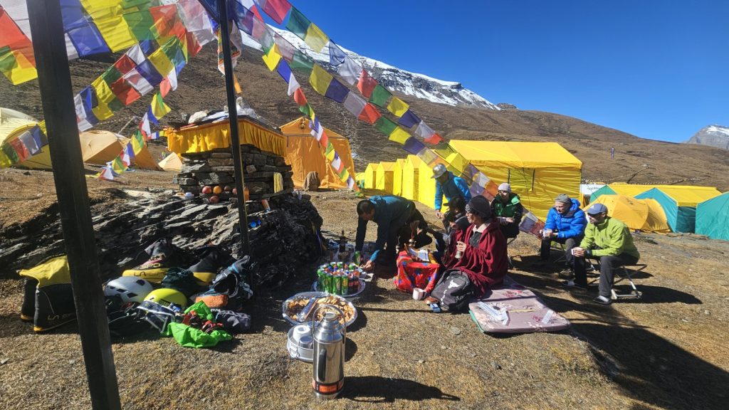
Day 8Himlung Himal Base Camp
Acclimatisation and technical preparation. The first day at base camp is for rest, a final equipment check and planning the activities that follow. We go through a detailed inspection of personal and communal equipment, check crampons, ice axes, climbing harnesses and communications equipment, while the expedition team monitors the health of all participants. We use the rest of the day for rest, hydration and preparing for the first rotations to the high camps.
- Expedition tents
- Full board
Day 9Himlung Himal Base Camp
Preparing for the first rotations. The day is devoted to final preparations and adapting to life at base camp. We check all the technical equipment, organise personal and communal expedition logistics and go through the plan for the coming days. The Sherpa team begins setting up equipment in the high camps, while participants use the day for rest, hydration and adjusting to conditions at almost 5,000 metres above sea level.
- Expedition tents
- Full board
Days 10–17Rotations Between the High Camps (C1 • C2 • C3)
- Grade (PSS)
- T3 K3 V2
Over the following days we carry out the acclimatisation plan through several rotations between base camp and the high camps. The number of ascents, the length of stay in the camps and the schedule of activities are adapted to the weather, the state of the mountain and the assessment of the expedition leader.
Camp 1 (approx. 5,450 m) – the first high camp is on a wide snow slope above base camp. The ascent to C1 is the first more serious contact with the conditions that prevail at great altitude.
Camp 2 (approx. 6,150 m) – the second camp is pitched on a spacious plateau beneath the final slopes of the peak. A stay at this altitude allows the body to adapt gradually to conditions above six thousand metres.
Camp 3 (approx. 6,375 m) – the last high camp is the starting point for the final ascent. We spend as little time here as possible, carefully monitoring the weather and the physical condition of all expedition members.
Between rotations we return to base camp for rest, recovery and additional acclimatisation. During this period the Sherpa team continues preparing the route, fixing ropes and carrying equipment to the higher camps.
- Expedition tents
- Full board
Note From base camp upwards, movement is on snow and ice, with the mandatory use of crampons, an ice axe, a climbing harness, a helmet and fixed ropes, which is why all the rotation days and the final ascent are graded with the technical grade T3. The biggest ascent in one stage is from C1 to C2 and is about 700 m.
Day 18Weather Window – Final Preparations
This day is reserved for final preparations and monitoring the weather forecast. Based on current meteorological data, the expedition leader determines the most favourable time for the final ascent. If weather conditions require it, the plan of activities may be adjusted so that the safety of all expedition members comes first.
- High camp
- Full board
Day 19Summit Day – Himlung Himal (7,126 m)7,126 m
- Altitude
- 7,126 m
- The ascent from C3
- approx. 750 m
- Activity duration
- 12–16 hours
- Grade (PSS)
- T3 K4 V2
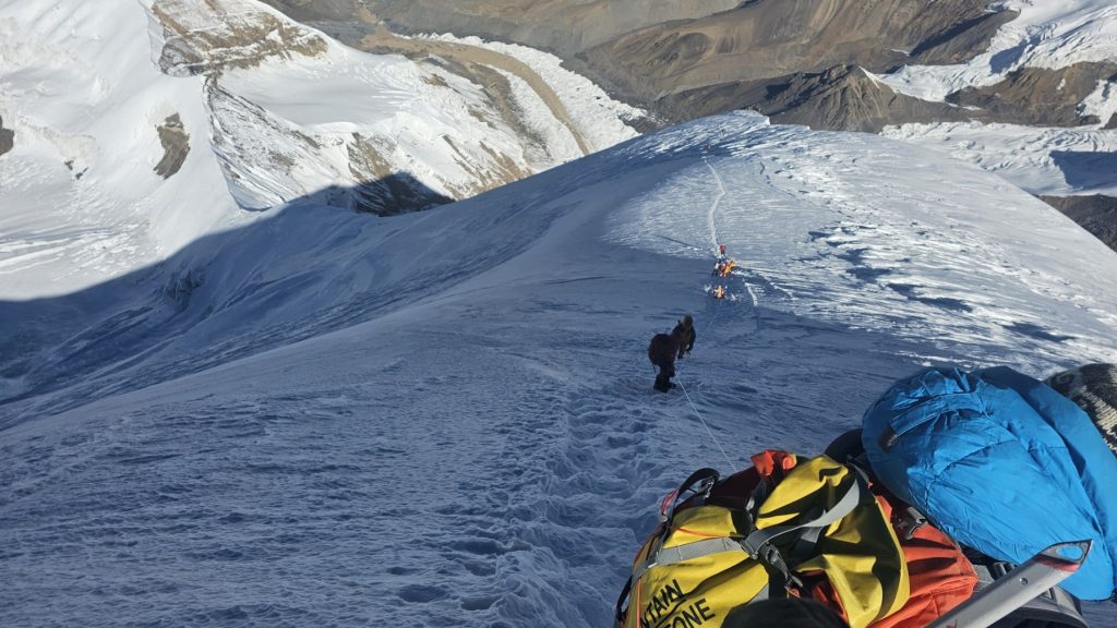
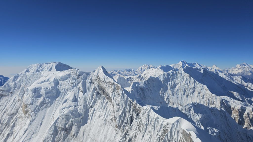
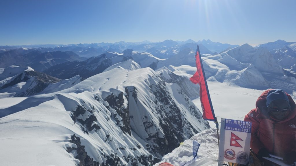
The most important day of the whole expedition. Departure from the last high camp is planned for the night hours. By the light of headlamps we begin the final ascent over snow slopes and glacial terrain, using crampons, an ice axe and fixed ropes on the more demanding sections. As we approach the summit, endless glaciers and the high peaks of the central Himalayas remain behind us. The last metres demand maximum concentration, patience and teamwork. Reaching the summit of Himlung Himal (7,126 m) is the culmination of the multi-week expedition – from the top there is a spectacular view of Annapurna, Manaslu, Kang Guru and the vast Tibetan plateau. After photographs and a short rest we begin a careful descent to the high camps, and then continue the return towards base camp.
- Expedition tents
- Full board
Day 20Himlung Himal Base Camp
After the successfully completed ascent all expedition members return to base camp, where rest, recovery and the unpacking of expedition equipment follow. This is the moment when impressions from the summit slowly come together, and the efforts of many weeks give way to a feeling of satisfaction at a successfully completed expedition. We spend the evening with a joint dinner with the Sherpa team and the base camp staff.
— RETURN FROM THE EXPEDITION ZONE —
- Expedition tents
- Full board
Day 21Himlung Himal Base Camp – Phu Gaon4,850 m
- Route
- Base Camp → Phu Gaon
- Altitudes
- 4,850 m → 4,080 m
- Walking time
- 5–6 hours
- Grade (PSS)
- T1 K2 V1
We leave base camp and begin the return through the Nar–Phu valley. After weeks in expedition conditions, returning among the stone houses and Buddhist monasteries of Phu Gaon brings a feeling of peace and satisfaction. The descent allows the body to recover gradually, and the view of Himlung Himal now has a completely different meaning.
- Lodge
- Full board
Note The return days are mostly descent. Since only ascent counts towards the V grade, these days carry the grade V1, even though more than 2,200 m of altitude difference is covered downhill in total. The use of trekking poles is recommended.
Day 22Phu Gaon – Meta4,080 m
- Route
- Phu Gaon → Meta
- Altitudes
- 4,080 m → 3,560 m
- Walking time
- 6–7 hours
- Grade (PSS)
- T1 K2 V1
We advance along the same route by which we entered the Nar–Phu region a few weeks ago. This time we see the landscape with different eyes – behind us are base camp, the high camps and Himlung Himal. We again pass through narrow gorges, stone bridges and plateaus along which yak caravans have passed for centuries.
- Lodge
- Full board
Day 23Meta – Koto3,560 m
- Route
- Meta → Koto
- Altitudes
- 3,560 m → approx. 2,600 m
- Walking time
- 6–7 hours
- Grade (PSS)
- T1 K2 V1
We descend through forests of pine and juniper, following the course of the Nar Khola river. After several days in a harsh high-mountain environment, returning to greener landscapes gives a completely different experience of the Himalayas. Arrival in Koto ends the trekking part of our expedition.
- Lodge
- Full board
Day 24Koto – Besisahar – Kathmandu
- Activity duration
- a full-day transfer
We leave the mountain region and return to Kathmandu. The road leads through the valley of the Marsyangdi river, past traditional villages, terraced fields and lush forests, which are a completely different landscape from what we have been used to in previous days. On arrival, check-in at the hotel and a well-deserved rest.
- 3★ hotel
- Breakfast
Day 25Kathmandu
The last day in Nepal is for rest and getting to know the cultural sights of the capital. We recommend a visit to Durbar Square, the Boudhanath Buddhist stupa, the Swayambhunath temple, or a walk through the colourful Thamel district, where there are numerous mountaineering shops, craft workshops and traditional restaurants.
- 3★ hotel
- Breakfast
Day 26Reserve Day
Expeditions in the Himalayas always depend on the weather. This day is provided as a reserve in case of unfavourable weather during the ascent or other unforeseen circumstances that may affect the pace of the expedition. If the spare day is not used in the mountains, we spend it in Kathmandu, with free time for rest, sightseeing or souvenir shopping.
- 3★ hotel
- Breakfast
Day 27Departure from Kathmandu
After breakfast and check-out from the hotel, a transfer to the international airport is organised. Participants then fly home on their own flights. This marks the end of one of the most beautiful 7,000+ m expeditions in the Himalayas.
Expedition facts
- Tour operator: Top Holidays Travel DOO Beograd, Ogranak EST Adventure
- Destination: Nepal
- Duration: 27 days / 26 nights
- Dates: October 11 – November 6, 2027
- Meeting point: Kathmandu
- Highlights: Kathmandu, Besisahar, Koto, Meta, Phu Gaon, Himlung Himal Base Camp, Himlung Himal (7,126 m)
- Highest point: Himlung Himal – 7,126 m
- Highest acclimatisation point before the summit ascent: Camp 3 – approx. 6,375 m
- Base camp: Himlung Himal Base Camp – approx. 4,850 m
- Character of the ascent: High-altitude trekking + an expedition ascent of a 7,000+ m peak
- Type of trip: A high-altitude Himalayan expedition
- Grade (PSS): highest grade on the expedition T3 K4 V2 (grades for each day are given with every walking day)
Transport
- All transfers airport – hotel – airport in Kathmandu
- Private transport Kathmandu – Besisahar – Koto and back
- All transfers according to the programme
Accommodation
- Accommodation at the Kathmandu Suite Home 3* hotel in Kathmandu, in twin rooms, 4 x bed and breakfast
- Accommodation in mountain lodges during the trek, in twin or triple rooms, 8 x full board
- Accommodation in expedition tents for two people at Himlung Himal Base Camp and the high camps C1, C2 and C3, 14 x full board
The Kathmandu Suite Home 3* hotel is not far from the Museum of Nepali Art and has a roof terrace with a lovely view of the city. The rooms are air-conditioned, each with its own bathroom (shower/WC) and TV. The hotel has a 24-hour reception and a restaurant.
Expedition price
Meeting Kathmandu: 5,350 EUR (without flights)
The price includes:
- All transfers according to the programme
- Private transport Kathmandu – Besisahar – Koto and back
- Accommodation at the Kathmandu Suite Home 3* hotel in Kathmandu
- Accommodation in mountain lodges during the trek
- Accommodation in expedition tents at base camp and the high camps (C1, C2 and C3)
- Breakfast in Kathmandu
- Full board during the trek and the whole expedition
- Complete communal expedition equipment (tents, kitchen equipment, ropes, fixed ropes, base camp logistics)
- A UIAA-licensed mountain guide
- Experienced Sherpa guides during the expedition at a ratio of 1:2
- High-altitude porters for transporting equipment between camps
- Porters for equipment during the approach to base camp
- The permit for Annapurna National Park
- The permit for entering the Nar–Phu region
- The permit for climbing Himlung Himal
- Organisation of the complete expedition
The price does not include:
- International flights to and from Kathmandu
- A visa for Nepal, if required for your nationality
- Travel health insurance that covers activities above 7,000 m, including the cost of helicopter evacuation
- Bottled water and drinks during the trek and the expedition
- Lunches and dinners in Kathmandu
- Tips for Sherpa guides, porters and local staff
- Additional nights in Kathmandu due to weather or changes to the expedition plan
- Personal expenses and anything not listed under “The expedition price includes”
Departures
- October 11 – November 6, 202727 daysThis page5,350 EUR
There is one scheduled departure for this tour right now. If the date does not suit you, write to us and we will let you know when we open a new one.
Booking conditions
Booking conditions:
Applying for the expedition means submitting:
- A short mountaineering CV
- A copy of a valid passport, for obtaining permits
PAYMENT AND CANCELLATION TERMS
Payment terms:
- 10% upon booking / non-refundable
- 40% no later than 60 days before departure
- 50% no later than 30 days before departure
If a participant cancels:
- If you cancel 59–30 days before departure, 50% of the total amount paid up to that point is refunded
- If you cancel 29 days or fewer before departure, the amount paid is not refunded
This programme is subject to the General Terms of Travel (PDF, in Serbian). Licence, travel guarantee and complaints: Agency information.
If the organiser cancels:
If the expedition is cancelled because too few participants have signed up, the organiser will notify applicants no later than 45 days before departure, with a refund of all payments made.
Requirements for participation
Himlung Himal is a serious high-altitude expedition intended for mountaineers with previous experience of ascents to great altitudes. To take part in the expedition, the participant must meet the following conditions:
- At least one successful ascent of a peak above 6,000 m
- Previous experience on expeditions with high camps is desirable
- Experience in using crampons and an ice axe and in moving on snow and ice
- A basic knowledge of climbing on fixed ropes and of descending techniques
- Excellent physical preparation for a multi-week stay in the high mountains
- A clean medical check-up and a sports-medicine certificate of fitness for staying at high altitude
- Travel health insurance that covers activities above 7,000 m and the cost of any helicopter evacuation
- Acceptance of the acclimatisation plan and all the decisions of the expedition leader for the duration of the expedition
- Previous experience on tours graded at least T3 K3 V2, according to the classification of the Mountaineering Association of Serbia
Based on the mountaineering CV submitted and previous experience, the organiser reserves the right to assess whether the programme suits the experience of the applicant.
Recommended gear
Personal gear
- Hiking backpack (about 50 l)
- A waterproof transport bag (90–120 l)
- Sleeping bag (comfort down to –20 °C)
- Sleeping mat
- Headlamp with spare batteries
- Sunglasses (category 4)
- Two thermos flasks and water bottles
- Personal hygiene items
Clothing
- Trekking trousers
- Gore-Tex jacket and trousers
- An expedition down jacket
- Down trousers
- Thermal base layers
- Fleece sweatshirts
- Hiking socks
- A hat for high altitude
- A cap or hat for sun protection
- Thin and thick expedition gloves
Footwear
- Trekking boots
- High-altitude double or triple expedition boots compatible with automatic crampons
Technical gear
- Crampons
- Ice axe
- Climbing harness
- Climbing helmet
- Ascender
- Descender
- Three prusik loops
- Three screwgate carabiners
- Trekking poles
Difficulty grading
All tours and ascents in our programmes are graded according to the Rulebook on the Safe Conduct of Mountaineering Activities (P 120), Article 22, of the Mountaineering Association of Serbia. The grade is always given in the same order: first the technical difficulty of the trail (T), then the length of walking in one day in hours (K), and finally the altitude difference covered in one day (V), for example T3 K4 V2.
The grades refer to a single day, not to the expedition as a whole, and are given with each day of the programme that includes walking or climbing. Please check before booking that your mountaineering experience matches the grades given in this programme.
T – Technical difficulty of the trail
- T1 – Easy trail. Walking without using the hands. The trail has no technically difficult sections or sharp changes in gradient, and is wide and well kept enough for less experienced hikers to move safely. Care and basic physical fitness are required. Trekking poles are recommended.
- T2 – Demanding trail. Leads through technically more difficult sections with a more pronounced gradient, where the hands are occasionally used for safety. Safety equipment and fixed aids are not necessary, but great care, good physical and mental fitness and mountaineering experience are required.
- T3 – Very demanding trail. Contains one or more very difficult technical sections with a steep gradient, where using the hands is necessary and wearing a helmet and other protective equipment is mandatory. On the harder sections a climbing rope, ice axe and crampons are used. Intended only for very experienced and physically and mentally well-prepared hikers. Not suitable for people who suffer from vertigo.
K – Length of walking in one day
- K1 – Easy: less than 5 hours of walking
- K2 – Moderately hard: 5 to 7 hours of walking
- K3 – Hard: 7 to 9 hours of walking
- K4 – Very hard: more than 9 hours of walking
V – Altitude difference covered in one day
- V1: less than 500 m
- V2: 500 to 1,000 m
- V3: 1,000 to 1,300 m
- V4: more than 1,300 m
Note on the V grade: the grade refers to the altitude difference covered on the ascent during one day. The descent is not counted in this grade, however large it is.
Important: To take part in this tour, participants must meet all three grades together. The PSS classification describes the technical, physical and altitude demands of a single day, but does not cover the additional factors typical of high-altitude expeditions – staying at extreme altitudes, living for several weeks in base camp and the high camps, the cold, exposure to the weather and distance from medical help. The best example is summit day itself: from C3 at 6,375 m to the summit about 750 m of ascent is covered, so that day carries the grade V2 on the scale, even though it lasts twelve to sixteen hours at an altitude above seven thousand metres. The camps are positioned so that no daily stage exceeds about 1,000 m of ascent. For this reason the grades on this expedition must be read together with the stated requirements for participation. In line with weather conditions, the state of the mountain and the assessment of the participants’ preparedness, the expedition leader reserves the right to adjust the plan or call off the ascent, with safety always taking priority.
Why EST Adventure?
- More than 25 years of experience in organising high-altitude expeditions and adventure travel.
- Proven Sherpa teams and local partners, with many years of experience on 7,000+ m peaks.
- UIAA-licensed mountain guides with extensive experience of leading expeditions to peaks above 7,000 metres.
- Carefully planned acclimatisation and logistics, based on the experience of numerous successfully completed expeditions.
- Safety, responsibility and team spirit are the core values of every EST Adventure expedition.
Important notes
- Travellers must give the agency a valid passport and a working phone number. The traveller is responsible for the validity of the travel document. The passport must be valid for at least 6 months after the date of return and have enough blank pages for entry into the country.
- Travellers must familiarise themselves with the regulations and entry requirements of the country they are travelling to, on the official websites of its authorities or of the country’s diplomatic and consular missions. They must also obtain all necessary travel documents and visas for themselves and their children and comply with the regulations of the countries they travel to, depart from or pass through.
- The organiser reserves the right to change individual elements of the programme in the event of unforeseen circumstances (weather conditions, safety reasons, changes in the work of local partners, flight schedules and the like), without affecting the overall quality of the trip.
- Travellers must have suitable travel health insurance, as well as insurance that covers high-altitude activities above 7,000 m, including the cost of helicopter evacuation.
- Visa and entry requirements depend on the country of your citizenship. Each traveller is responsible for checking the current entry, transit and visa rules for their own passport well before departure and for obtaining all the necessary visas and travel documents.
- Travellers must respect the local laws and customs of the country they are visiting, as well as the instructions of the guide and the agency’s representatives during the programme.
- The signatory of the contract or the group representative must inform the other travellers about the travel programme, the payment terms and the General Terms of Travel of EST Adventure.
- Minors travelling without one or both parents must have a certified parental consent for crossing the border, in accordance with the applicable regulations.
- By signing the travel contract, the traveller confirms that they are familiar with the travel programme, the payment terms and the General Terms of Travel of EST Adventure.
- The strength of the Wi-Fi signal depends on the quality of the signal provided by the local provider chosen by the owner of the accommodation and on the number of users on the network at the time. The organiser cannot influence the quality of the Wi-Fi connection and is not responsible for it.
- In some accommodation the third and fourth beds may be extra beds. The size and appearance of an extra bed depend on what the accommodation can offer.
- Some additional facilities of the accommodation are available for an extra charge (safe, parking, minibar, TV, air conditioning…).
Tour operator
Please read the General Terms of Travel carefully. The tour operator is the travel agency Top Holidays Travel DOO Beograd, Ogranak EST Adventure, Varovnička 4a, 11406 Mladenovac, registration number: 21715182, licence OTP 22/2026, category A. The General Terms of Travel of the tour operator apply to this programme.
Program HIMLUNG HIMAL EXPEDITION 2027 br. 1 od 20.07.2026.
Book or ask us anything
The tour and date are already filled in: Nepal – Himlung Himal (7,126m), October 11 – November 6, 2027. No payment is needed to sign up.
 Georgia
 Russia